La Candelaria’s Vertical Maze
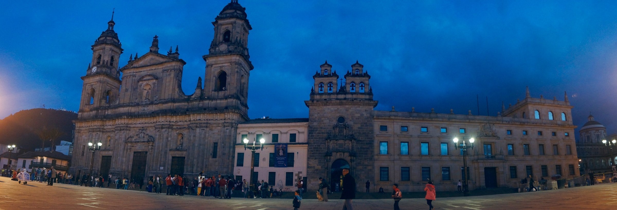
You start at Plaza de Bolívar because everyone does, but the real lesson comes when you try to walk two blocks uphill. At 2,640 meters the air holds 25% less oxygen than sea level. Your lungs notice before your brain does. Locals stride past while you pause to study a colonial doorway, catching your breath without admitting that’s what you’re doing.

The historic center climbs the base of Monserrate in terraces that predate any planning commission. Carrera 7 follows a ridgeline. Calle 11 drops into a gulley where motorcycle taxis wait for passengers who’ve given up on the gradient. You’ll see businessmen in suits taking these motos rather than walk three blocks uphill. Nobody judges. The altitude doesn’t care about your fitness level.
Colonial houses tilt at odd angles because the Spanish built where the mountain allowed, not where geometry wanted. Sidewalks narrow to single-file between stone walls. When it rains, water sheets down Carrera 4 like a creek. The topography creates dozens of microclimates within six square blocks. One corner gets morning sun, the next stays damp until noon, and that affects which vendors set up where.
Monserrate’s 500-Meter Wall
The mountain faces Bogotá as a green wall rising 500 meters above the city grid. On clear mornings you can see the white sanctuary at the summit from fifty blocks away. Most days it vanishes into cloud by 10am. The altitude creates its own weather. Rain that hasn’t reached the city yet is already falling on Monserrate.
The teleferico and funicular haul tourists up in eight minutes, climbing what takes two hours on foot. The pilgrimage trail gains 830 meters of elevation through cloud forest that drips even when it’s not raining. I’ve watched visitors from Cartagena and Santa Marta, sea-level Colombians, stop every hundred meters to rest. The thin air doesn’t distinguish between tourist and local, only between who lives at altitude and who doesn’t.
At the top the sanctuary sits in a climate zone you didn’t pass through on the drive from the airport. It’s five degrees colder. Wind gusts with nothing to slow them. Vendors sell agua de panela (unrefined cane sugar dissolved in hot water, COP 2,000 or $0.50) because everyone needs the calories after that climb. On Sundays you’ll see families who’ve been making this pilgrimage monthly for decades, and they’re still breathing hard at the summit.
Chapinero’s Terraced Grid

Bogota
North from La Candelaria the city climbs in steps. Chapinero sprawls across four different elevation bands, each with its own commercial ecosystem. Zona G’s upscale restaurants cluster on flat ground at 2,600 meters where valet parking works. Three blocks uphill Chapinero Alto’s bars occupy steeper streets that flood when afternoon storms overwhelm the drainage.
The topography segregates. Wealthy neighborhoods hold the eastern slopes where morning sun arrives first and the air is fractionally thinner and cleaner. Working-class barrios occupy the western flats toward the airport where smog settles. This isn’t subtle policy, it’s physics. Cold air sinks, pollution follows, and the mountain geography channels everything west.
Carrera 7 runs north-south for 35 kilometers but gains 400 meters of elevation doing it. TransMilenio buses labor uphill in first gear. Going south toward the airport they coast. Cyclists learn which routes gain altitude gradually versus which ones spike 80 meters in four blocks. The bike-lane network looks democratic on a map but the mountain makes some routes punishing.
Usaquén’s Mountain Frontier
The city ends where the mountains begin in earnest. Usaquén marks the northern edge of walkable urbanism. Beyond it roads switchback toward Páramo de Chingaza, the high-altitude grassland ecosystem that starts around 3,200 meters. The temperature drops one degree for every 150 meters of elevation. Twenty minutes north of Usaquén’s Sunday flea market you’re in landscape that frosts overnight year-round.
Expensive houses push up the mountainside on streets that become trails. Colombians with family money built here for the views and the excuse to own an SUV. The city grid fragments into cul-de-sacs and gated communities clinging to slopes at gradients that require retaining walls. When it rains these neighborhoods flood downhill into older construction that was there first.
The boundary between city and mountain isn’t legal, it’s atmospheric. Trees change species. Crops grown in valley farms don’t produce above 2,900 meters. The air gets noticeably thinner. I’ve watched runners train on Calle 170 near the mountain base because the extra 300 meters of altitude makes a difference they can measure in split times. Bogotá’s altitude is borderline for human habitation, and Usaquén sits at the high edge of that borderline.
Soacha’s Downhill Sprawl
South from the airport the city descends into Soacha, technically a separate municipality but functionally Bogotá’s overflow. This is where altitude works in reverse. At 2,560 meters, 80 meters below Plaza de Bolívar, the air holds marginally more oxygen. It’s also warmer by half a degree, which sounds trivial until you’re the family living in a brick house with no heating.
Developers built here because flat land is cheaper than mountain slopes. The savanna extends south for kilometers without the topographic obstacles that fragment northern Bogotá. Streets run in grids. TransMilenio reaches Soacha because the route doesn’t require tunnels or switchbacks. But the lower elevation means worse air quality. Smog from eight million people and two million cars settles here overnight. Mornings smell like diesel.
The altitude gradient creates invisible pressure. Water flows downhill naturally so southern neighborhoods have better pressure than Usaquén’s mountain suburbs where pumps run constantly. Sewage works with gravity. Even internet service follows the terrain because fiber-optic cables cost more per meter when you’re trenching uphill through rock. The mountain doesn’t just shape where people live, it shapes which utilities reach them reliably.
If you liked this, you might like: Lima, Toronto, New York.
Planning the trip? compare flight deals from Stavanger, Oslo, Bergen, and Trondheim.