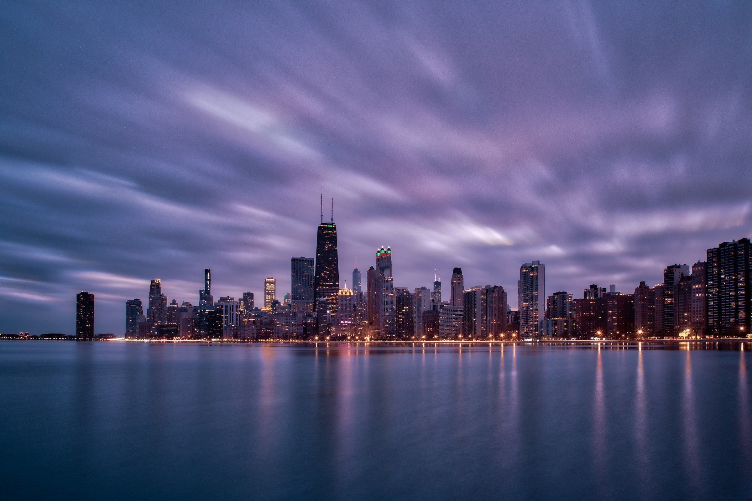
The skyline packs in like teeth because there’s nowhere else to go
Stand at the mouth of the Chicago River where it meets Lake Michigan and turn west. Every glass tower, every limestone office block, every converted warehouse is pressed shoulder to shoulder inland. The lake is the hard stop. Cities like Los Angeles sprawl because they can. Chicago went vertical and dense because 26 miles of lakefront said “this far, no further”. The result is a downtown that feels like a fist, tight and deliberate. No suburban fade at the edges of the Loop. Just full intensity until you cross into neighborhoods that have their own concentrated cores.

Chicago
You see it clearest in winter. The wind comes off the lake with nothing to slow it, funnels between those packed towers, and turns every intersection into a wind tunnel. Locals call it the Hawk. It’s why the Pedway exists, that network of underground tunnels connecting buildings downtown. Nobody brags about it to tourists, but the first serious cold snap will teach you why 40 blocks of climate-controlled passageways under the Loop matter.
Neighborhoods stack against each other instead of bleeding out
Chicago doesn’t do gradual transitions. Cross Western Avenue northbound and you leave Ukrainian Village, enter Bucktown. The pierogi shops stop. The vintage furniture stores start. Four blocks later you’re in Wicker Park and the rent jumped $400. It’s not subtle. The lake forced density, and density made borders sharp.
Pilsen still has murals in Spanish covering entire building sides on 18th Street. Walk north across the expressway and you’re in the South Loop where new condo towers sell for $650,000. The distance is 12 minutes on foot. The demographic shift is immediate. Other cities have neighborhoods that melt into each other. Chicago’s butt up like Tetris blocks because there was never room to soften the edges.
This makes the city easier to read than people expect. River North is River North. You know what you’re getting. West Loop has restaurants that cost $85 per person and warehouses converted into offices for tech companies that moved from San Francisco. Logan Square is where the bartenders from those West Loop restaurants live. The lake compressed everything into defined zones.
Public transit proves the lake is in charge
The CTA rail lines run in and out like spokes, all of them terminating downtown or curving to avoid the water. The Red Line goes north and south parallel to the shore. The Blue Line runs northwest because that’s the only direction available. The Pink, Orange, and Green Lines arc west and south. None of them cross the lake because the lake is a wall.
This makes downtown unavoidable. You can’t bypass it. If you live in Andersonville and work in Bridgeport, you route through the Loop. A $2.50 fare (about $2.50 USD) gets you anywhere, but the system is built around that compressed core the lake created. The buses that run east-west along streets like Fullerton or Belmont dead-end at the lake, turn around, head back inland.
Metra commuter rail is the same. Trains come in from suburbs to the west and north, dump everyone at Union Station or Ogilvie, stop. The lake is the period at the end of the sentence. You don’t keep going. There’s water.
The Lakefront Trail is 18 miles of what the city isn’t allowed to touch

Chicago
Daniel Burnham got his way in 1909. The lakefront stays public. No private development, no hotels with lake views, no condos on the water. Just parks, beaches, a bike path that runs from Edgewater to Hyde Park. The rule held. Chicago is the only major U.S. city where wealth couldn’t buy the shoreline.
This created a strange pressure. All that density inland, all those people crammed into neighborhoods west of Lake Shore Drive, and the valve is a paved path where cyclists commute at 7am and families grill on cheap portable grills at Montrose Beach when the weather allows. On warm weekends, the trail is wall-to-wall. Rollerbladers. Runners. People walking dogs. Everyone using the same 18-mile strip because it’s the only horizontal space that didn’t get built over.
The beaches are narrow. North Avenue Beach gets so packed the sand disappears under towels. Oak Street Beach is smaller and somehow even more crowded. The lake made the city dense, then refused to provide much relief from that density. The Lakefront Trail is what you get. Use it or stay in the press of buildings.
The winter lakefront is why nobody pretends this is a year-round paradise
Mid-winter off Fullerton Avenue, the lake freezes in chunks near shore. The Hawk is 15 degrees with wind that feels like 2. The trail empties. Tourists who visit during warm months think Chicago is manageable. People who live here know the lake flips from amenity to enemy depending on the calendar. The same water that makes summer bearable turns winter into something you survive.
The density that makes Chicago interesting when it’s warm makes it oppressive when it’s freezing. Tight streets, tall buildings, wind with no place to disperse. The lakefront becomes hostile space. The beaches close. The parks are gray and empty. You can walk the trail if you want to punish yourself, but mostly people stay inland, compressed into the bars and restaurants that stay warm.
This is part of the deal. The lake stops the city from sprawling into formless metro area. In exchange, it makes winter miserable. Chicago wouldn’t be Chicago without both conditions. The containment creates the intensity. The intensity creates the culture. The culture accepts that four months a year, the city’s defining geographic feature is trying to kill you.
Uptown and Edgewater exist because the lake ran out of room
The North Side pushed as far as it could go before hitting Evanston. Uptown and Edgewater are what happens when density has one direction left. Old theater palaces like the Aragon Ballroom. Six-story apartment buildings with 40 units each. Argyle Street with Vietnamese restaurants and bakeries that sell bánh mì for $6.50. It’s crowded because it had to be.
The same dynamic played out south. Hyde Park, Bronzeville, South Shore, all built up because the lake said stop and the city had to make room somewhere. The Metra Electric Line runs down the shore because there’s a thin strip of land between the water and the neighborhoods that needed transit. Every decision came back to the same geographic fact.
Chicago is what happens when a city has a wall on one side. It didn’t sprawl. It couldn’t. The lake made it pack in, go vertical, define its borders, and live with the consequences. The consequences are sharp neighborhoods, brutal winters, a Pedway, and a downtown that feels like the only place in America where density still means something. The lake made Chicago Chicago. Everything else followed.
If you liked this, you might like: Mexico City, San Francisco.