
You arrive in Asunción expecting a capital built on a grid, some colonial core surrounded by planned expansions. What you get instead is a city shaped by water that rises and falls on a schedule nobody controls. The Paraguay River doesn’t flood catastrophically here. It just swells, predictably, claiming the same low ground every year between December and March. The city grew around this rhythm, not against it.
Asuncion
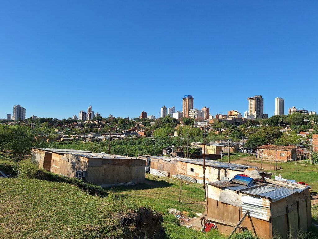
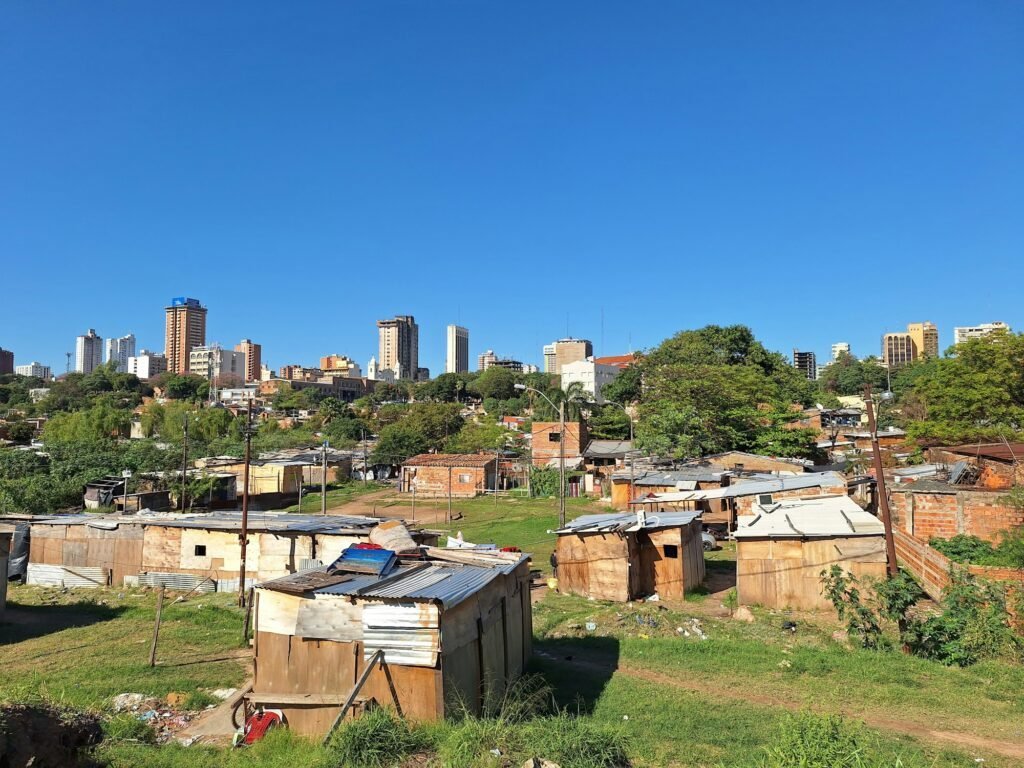
Walk from the microcentro toward the river and you’ll notice the terrain drop. Not dramatically, but enough that certain streets end in chain-link fences and hand-painted signs warning about water. These aren’t flood barriers in the emergency sense. They’re acknowledgments. The bañados, the low wetlands along the river’s eastern bank, house around 300,000 people in neighborhoods that exist in a permanent state of semi-occupation. When the water comes, some families move furniture to upper floors. Others wade through knee-deep streets for weeks. By April, the river retreats and life resumes at ground level.
This isn’t poverty tourism. It’s the structural fact that determines where highways go, which neighborhoods get investment, and why the wealthy live on the hills to the east while informal settlements sprawl along the water. You can see the division from the Costanera, the riverside avenue that runs along higher ground. Below it, houses on stilts. Above it, gated communities with names like “Villa Morra” and “Manorá.” The altitude difference is maybe 30 meters. The economic difference is everything.
The River Decides What Gets Built and What Gets Abandoned
Asunción has no metro, no light rail, no commuter train. The bus system runs on routes that avoid the bañados entirely during wet months, which means the poorest residents either walk through flooded streets or pay mototaxi drivers double to navigate the water. I watched a city planning map at the Municipalidad office that showed proposed infrastructure projects. Every bridge, every drainage canal, every paved road stopped at the same contour line. Below that elevation, the river wins.
This creates a strange development pattern. Shopping malls, office towers, and hotels cluster in a narrow strip along Avenida Mariscal López and Avenida España, both built on the ridge that stays dry. Drive five blocks downhill toward the river and you’re in unpaved streets, houses with corrugated metal roofs, and drainage ditches that double as open sewers when the river rises. The city expands east and south, never west. West is water.
Real estate prices follow the topography exactly. A two-bedroom apartment in Villa Morra costs $120,000 USD. The same square footage in Banco San Miguel, three kilometers away and ten meters lower, runs $30,000. Developers don’t build in the bañados not because of zoning but because foundations crack, walls mildew, and buyers know the water will return. The informal settlements aren’t slums waiting for gentrification. They’re the only housing option for people who can’t afford altitude.
How Flooding Becomes Infrastructure
Asuncion
The paradox is that the river made Asunción possible in the first place. Before roads, before rail, before airports, the Paraguay River moved goods between the Atlantic and the interior. The port at Asunción was the transfer point where riverboats met ox carts heading to the interior. The city grew as a logistics hub, not a defensive fort or a mining camp. When the river floods now, it’s shutting down the reason the city exists.
You see this tension at the Puerto de Asunción, the old port district that’s been half-abandoned since container shipping moved to deeper waters downstream. The warehouses are still there, rusted and empty. Some have been converted into event spaces that flood every year and then get hosed out and reopened. Others just sit. The city tried to redevelop the port in 2008 with a plan for condos and restaurants. The river flooded that year and the investors pulled out. Now there’s a flea market on Sundays and not much else.
Meanwhile, the informal economy has figured out how to work with the floods. During high water, vendors in the bañados sell from boats. Not tourist boats, just wooden canoes loaded with vegetables, propane tanks, phone credit. The streets become canals and commerce continues. When I asked a woman selling empanadas from a canoe why the city doesn’t build levees, she laughed. “They tried. The river went around them.” She wasn’t wrong. Asunción has 40 kilometers of riverfront and the money to protect maybe five.
Why the Wealthy Stay on the Hills and the Poor Stay Near the Water
The simple answer is that nobody with options chooses to live where their house floods. But it’s more specific than that. The bañados aren’t just cheap housing, they’re free housing. Most residents don’t own the land, they occupy it. The government can’t sell it because it’s technically floodplain. The owners can’t develop it for the same reason. So people build, and the city provides intermittent electricity and water but no sewage, no paved roads, no flood defenses. It’s an accidental compromise: the poor get housing, the state avoids a slum clearance fight, and the river gets to flood on schedule.
The wealthy, meanwhile, have moved steadily east into neighborhoods like Carmelitas and San Vicente, where the elevation tops 100 meters and the river is a distant view. These areas have private trash collection, private security, and streets that drain. They’re not gated in the obvious sense but they might as well be. A bus from the bañados to Villa Morra costs 2,500 guaraníes ($0.35 USD) and takes 90 minutes because the route loops around the low ground. A taxi costs 40,000 guaraníes ($5.50 USD) and takes 20 minutes. If you’re working two jobs in the bañados, you’re not commuting to the hills.
This geography produces a city where your altitude predicts your income, your access to jobs, and whether you spend January moving furniture or going to the pool. Asunción’s urban plan, such as it is, isn’t written by planners. It’s written by the river, which floods the same neighborhoods every year and guarantees they’ll stay poor. You can see the whole system from the Costanera at sunset: the high ground glittering with lights, the low ground dark except for cooking fires, and the river between them, indifferent.
If you liked this, you might like: Panama City, Cusco, Cancun.